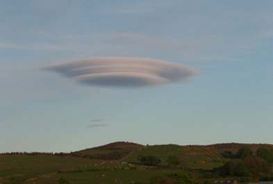
UFO Cloud Spotted Over Golf Club In Wales
 IS it a wind turbine? Is it an Martian? Is it a…cloud? It is a cloud.
It’s a cloud over Borth golf club, mid-Wales.
The locals are pointing.
This strange apparition hovered over the British coast for almost an hour and was captured by Sonja Lewis as she worked at Borth Golf club, Mid Wales.
“I’d never seen anything like it before it was like four clouds piled up on top of each other,” she said.
“It was quite beautiful.”
“It stretched from hole one of the golf club right over to hole 18 and everyone could see it.
Aliens are coming for the golfers first. You can learn to love an alien. Golfers the ideal specimens, being already pickled in bile and gin, and dipped in a smug coating of self-satisfaction. Beam me up, Snotty.
Lenticular clouds, also known as wave clouds, are the most common member of an unusual class of clouds that remain stationary while the wind blows through them. They are normally generated by mountains, and almost every place in Alaska has enough mountains to allow wave clouds to be observed. They form because of two fundamental properties of air and water. First, when air is lifted and expanded, it cools. This is why temperature normally decreases with height. Second, as air cools, the amount of water it can hold decreases. If air that is already holding almost as much water vapor as it can hold is lifted and thus cooled, the water will condense out fairly promptly onto any particles that may be in the air, forming a cloud. If the air is dry to start with, the air has to be lifted much farther before a cloud forms. When the air descends again, it is warmed, and the cloud droplets evaporate.
Now suppose a wind is blowing over a mountain, being lifted on the upwind side, descending and warming on the downwind side, and flowing in a smooth arc over the top of the mountain. If the humidity is high to start with, a solid ceiling of clouds will form, hiding the mountain. If the air is very dry, it may not be cooled enough to produce a cloud at all. But if most of the air is dry, with one or two thin layers that are wetter, clouds will form only in the wet layers. As the air rises, droplets form in the moist layer a little upwind of the mountain peak. These droplets are carried along in the wind as the air arcs over the mountain; as the air descends and warms on the lee side, the droplets evaporate. Individual droplets move through the cloud with the wind, while the cloud as a whole stays fixed over the mountain. If the air is flowing over the mountain in a smooth arc, the cloud will follow the shape of the air flow, and resemble an upside-down saucer. If there are several wet layers in the air, with drier layers between them, a wave cloud may form in each layer. The technical name for such a cloud formation, pile d’assiettes, actually translates as “pile of plates”. Given that these plates in the sky are upside down, it is a very good description of their appearance.
Or it’s aliencs making a smoke screen…
Posted: 19th, January 2009 | In: Photojournalism, Strange But True Comments (6) | TrackBack | Permalink


